| |
| |
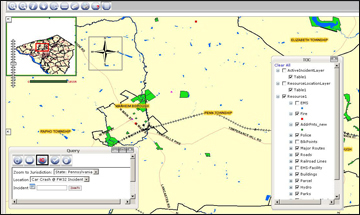
GIS Mapping |
|
|
GIS Mapping helps users gain greater situational awareness. Built using ESRI ArcGIS Server technology, users can zoom in to points, zoom out, scroll around the map, and search the map. Users may use an identify feature in order to identify specific features on the map by clicking on it. All locations can be mapped and various types of spatial analysis can be provided such as a answering the questions, “What are the closest resource points?”, “Where is the incident command post?”, and “Where are the closest hospitals and how long will it take to get the injured there?” Various map icons are used to help users differentiate between the various type of incident facility. For all addresses that cannot be found on the map, users may pick a point on the map to capture the map coordinates for the address, enabling the user to map that location from that point on. The system enables users to mark information such as road blocks on the map. |
|
|
|
|
| |
|
|
| |